
Lyndhurst Street Directory, Address First
Use the same address through each system, including its unit or qualifier. An assessment record can identify an apparent owner and parcel, while a deed records a transaction. A voter list or historical directory can place a named person at an address for a particular election or publication period. Those results should stay separate in a Lyndhurst street directory search. A name on one source does not convert the source into proof of every other fact.
- Standardize the address with USPS, preserving the street direction, suffix, unit, city, state, and ZIP.
- Search the tax record by location to identify the apparent owner and the block, lot, qualifier, and parcel details shown.
- Check the same location in the Parcel Viewer for the current parcel shape, frontage, and adjacent parcel context.
- Use the apparent owner or grantee in the County Clerk index, then compare the legal description and parcel identifiers through the deed chain.
- For an election-period listing, use the lawful county voter-list request route; for an older address listing, check the directory address section and then the alphabetical section.
That sequence is deliberately address-led. It helps prevent a mailing address, a similar street name, or an unconnected same-name party from being assigned to the target parcel. For a historical household trail rather than a current street-by-street check, the regional volumes are discussed in the Lyndhurst city directories.
Lyndhurst Street Addresses, Standardized
Begin with the USPS ZIP Code Lookup before opening the property portals. Its By Address mode asks for a street address, city, and state, and accepts an apartment, suite, or other secondary designation and ZIP where available. It can return a standardized postal format and ZIP+4. It cannot confirm that a particular person or organization is at the address, and a postal boundary is not a parcel or municipal boundary.
If several results appear, add the unit and ZIP rather than discarding the secondary address. That small detail matters for a qualified parcel or multi-unit street number.
Lyndhurst Street Directory Tax Keys
The County Board of Taxation links the public Bergen Property Record Search. Its visible setup controls include database, county, district, search format, output format, and items per page. The live values for those dropdowns were not exposed in the research, so use only the options the portal displays. The field set below is the useful part of the Lyndhurst street directory workflow.
| Portal field or control | Use for an address search | Research limit |
|---|---|---|
| Location | Enter the property location or street criterion. | Wildcard behavior was not exposed. |
| Owner Name | Try the assessed owner when location does not resolve. | Test spelling and name order in the live portal. |
| Block | Narrow to the tax block. | Use with the parcel record. |
| Lot | Identify the tax lot. | Keep it with the block. |
| Qualifier | Distinguish a unit or qualified parcel where used. | Do not strip it from the address. |
| Process | Run the selected search. | Choose displayed output and page controls first. |
The property-search capture documents those controls rather than a completed Lyndhurst result.
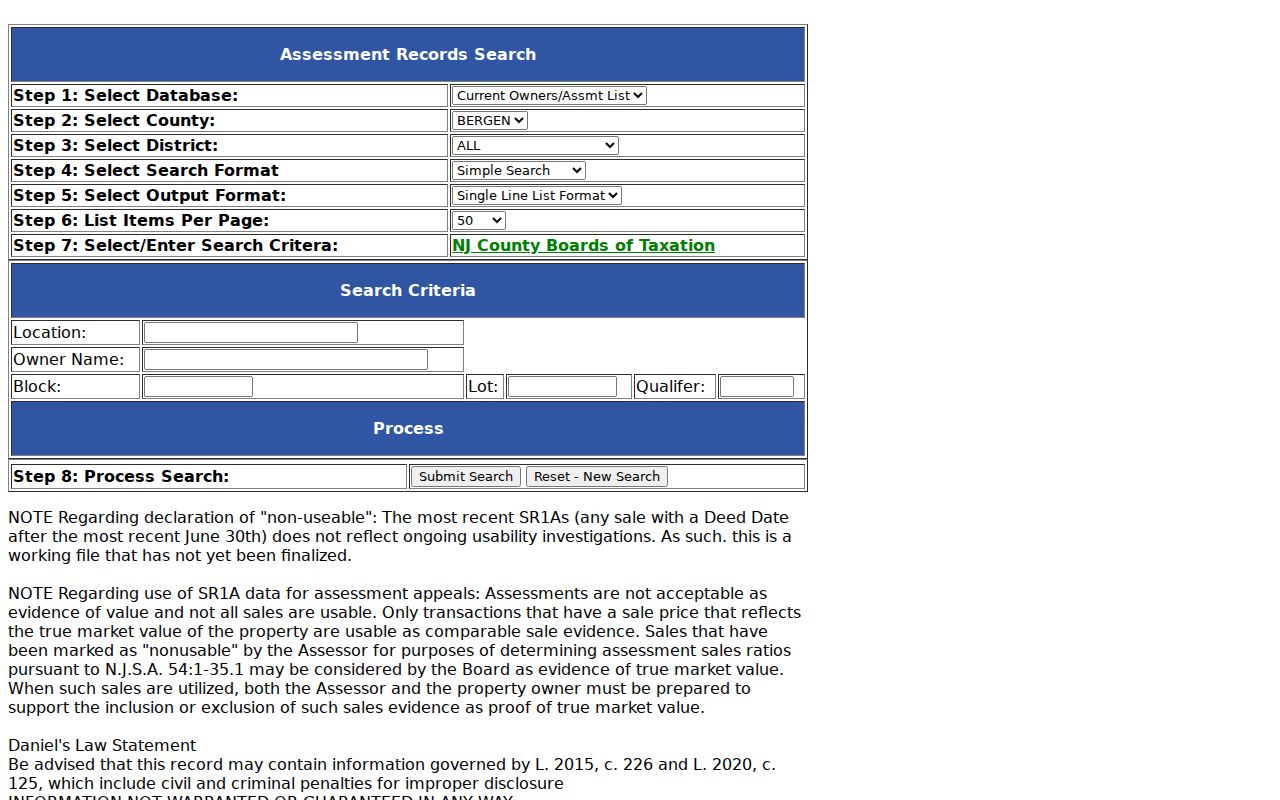
Save the search date and parcel identifiers with any result. The portal says recent SR1A sales after the most recent June 30 may not be finalized and displays a Daniel’s Law warning about withheld protected information.
Lyndhurst Street Records: Situs Matters
New Jersey’s MOD-IV guidance separates an owner block from the physical Property Location. The owner’s street, city, state, and ZIP are mailing fields. The property location, also called the situs, is the actual parcel location. A person can receive tax mail outside Lyndhurst while the situs remains on a Lyndhurst street. Treating the two addresses as interchangeable creates an avoidable wrong-street match.
- Parcel
- A tax or GIS unit of land, commonly identified here with block, lot, and sometimes qualifier information.
- Situs address
- The physical location assigned to the property, not necessarily the address where the owner receives mail.
- Plat
- A recorded map or plan used to describe land. It can help with an older legal description, but it is not a current occupancy record.
- Criss-cross directory
- An address or street section in a directory that can be read from number to listed name, if that particular volume includes one.
Keep the original spelling of a street from every record. A changed abbreviation, a missing unit, or a former municipal label may be the reason two results do not line up.
Lyndhurst Street Parcels and GIS
The Bergen County Parcel Viewer gives the current spatial layer for an address after the tax search. Use it to compare the target parcel with adjacent parcels and to confirm that the situs is in the expected place. Its controls and layers are JavaScript-driven and were not available for a field-by-field research inspection, so no particular map filter or button should be assumed.
Parcel geometry is not a survey. The statewide NJGIN parcel data also cautions that parcel edges may not match county boundaries exactly and that owner names may be redacted under Daniel’s Law. A blank protected field does not mean that the parcel lacks an owner. For viewer or data questions, the Bergen County GIS office lists 201-336-6446 and gis@bergencountynj.gov.
Adjacent street numbers are not automatically the same tax block or even touching parcels. Compare the viewer’s parcel shape with the block, lot, qualifier, and situs fields before treating a nearby number as related.
Lyndhurst Street Deeds Since 1970
The Bergen County Land Records Search provides an online deed and mortgage index from January 1, 1970 forward. Search the apparent owner as a grantee and search spelling variants. When a matching instrument appears, record the grantor, grantee, document type, recording date, book and page or instrument number, and any municipality or block-and-lot details the result actually shows.
Advanced functions may need the browser compatibility steps noted by the Clerk. Basic search is the documented fallback when an integration tool does not run. A deed index hit records a transaction, not proof that someone is currently at the address.
For an older instrument, preserve the last known book, page, or film clue and use the New Jersey State Archives county-deed microfilm route or Bergen historical collections. The online cutoff is not a claim that title began in 1970.
Lyndhurst Street Records by Address
Street evidence has different time ranges and different limits. Use the record that fits the question, then label what it actually supports. This prevents a property record from being treated as a present-person list or a map from being treated as a survey.
| Address record | Coverage | Useful keys | What it supports |
|---|---|---|---|
| USPS address lookup | Current postal addressing | Street, unit, city, state, ZIP | Standardized mailing format, not identity. |
| Bergen tax portal | Current tax database | Location, owner, block, lot, qualifier | Parcel and assessed-owner mailing clue. |
| Parcel Viewer and NJGIN | Current map and parcel data | Address, parcel, map interaction | Shape, location, and adjacent-parcel context. |
| Bergen deed index | Online from January 1, 1970 | Party, document, date, book/page | Recorded transfer chain. |
| State Library directories | 1897–1899 and 1909–1926 listed runs | Street, number, surname | Historical address listing. |
| The Leader archive | 1928–2010 | Name, street, year, organization | Local notices and corroborating clues. |
A parcel identifier links the tax record to the title work. The street wording links postal normalization, directories, and local notices. Keep the source date beside every name, particularly when a long-standing street directory search spans more than one era.
Lyndhurst Street Voter List Limits
New Jersey registry lists are arranged by street and residence number, but access is controlled by statute. The live New Jersey Am I Registered? tool was not available for unrestricted third-party searching during the research inspection. For a formal list, the Bergen County Clerk’s voter-registration service route calls for a written request that identifies the election district and date range instead of a broad name collection.
State law withholds signatures and protected identifiers. A list can reflect an election-period registration, an inactive entry, or an old address. Report it as registered or listed for that period, not as a blanket conclusion about current residence.
Lyndhurst Streets in Regional Directories
Older Lyndhurst street directory work has a catalog trap: the most useful listings are often under Rutherford or Passaic-area titles. The New Jersey State Library directory finding aid identifies Passaic volumes for 1897–1899 and Richmond’s Rutherford-area directories for 1909–1924 and 1926. The volumes from 1917–1924 use the label “Lyndhurst Township.” Preserve that original label in your notes.
Start with the address section when it exists, then check the alphabetical section for the same surname. Not every regional volume has a usable reverse section, and absence in an inspected volume can mean noncoverage, a spelling change, a different directory policy, or an unreadable page. It is not proof that a building was empty.
For the period after 1928, The Leader’s digitized archive can add notices around a street or family name, but inspect the newspaper page rather than relying only on OCR.
Lyndhurst Street Names Need Verification
The 1915 Sanborn sheets cover Lyndhurst and Kingsland and can supply built-environment context, such as street layout, building footprint, use, construction material, and landmarks. They do not name ordinary occupants and do not replace a current parcel map. Compare a historic sheet with a deed, tax map, or directory entry before connecting a past number to a current address.
No official local street-renumbering, annexation, or complete historical street-name schedule was located. Do not infer a renumbering from a changed number alone. Flag the question and compare the legal description, directories, Sanborn sheets, tax maps, and municipal ordinances where available.
Note: A regional directory heading such as Rutherford does not change the municipality of a Lyndhurst parcel.
Lyndhurst Street Directory Citations
Save enough detail to repeat a street-by-street result. For a tax record, note the search date, property location, block, lot, qualifier, and parcel identifier. For a recorded instrument, preserve the party roles, recording date, document type, legal description, and book-and-page or instrument reference. For a directory or newspaper, keep the volume or paper title, year, printed street heading, number, page, and the source image or page link.
A citation also keeps uncertainty visible. Write “not found in inspected volume” when a directory search did not produce an entry. Mark a map question as parcel context rather than a survey result. If older and current street numbers do not align, record the mismatch and the records compared. That history is more useful than a tidy but unsupported street directory conclusion.
Lyndhurst Street Directory Privacy Boundaries
No official complete current resident list was located for Lyndhurst. Tax data, deeds, a voter-list request, and historic directories are separate record types with their own time limits. They do not establish every person connected to an address. New Jersey’s Address Confidentiality Program can supply a legal substitute address, and Daniel’s Law can require redaction of protected residential information on government websites.
Honor a redaction as a stop sign. Do not try to reconstruct a protected physical address from a parcel, voter, deed, map, or other source. New Jersey MVC records are also restricted under the Driver Privacy Protection Act rather than being an ordinary street-directory source.
Lawful use. Use Lyndhurst address records for personal, lawful research, family history, estate questions, or property context. Never use them to stalk, harass, intimidate, or defeat a protected-address safeguard.